Introducing the New Fishing Theme
Updated 11/25/25
Navigating the Portal’s fishing data just got easier. Our deep collection of maps showing commercial fishing activities and management areas has been reorganized into a new and improved Fishing theme, now available in Marine Planner.

The changes were guided by input from members of the region’s fishing industry on how to make it more intuitive, while also taking advantage of recent technical upgrades that enabled new options for arranging data on the Portal.
Among the most prominent changes, the Portal’s maps are now organized by fishery or fishery management plan (FMP) rather than data type. For example, users looking for maps pertaining to scallops or striped bass can now find all related maps grouped together in one place, rather than having to sift through long lists of Vessel Monitoring System (VMS) or Vessel Trip Report (VTR) products.
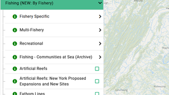
When accessing the “Fishing (NEW: By Fishery)” theme, users are now presented with a few data options:

- Fishery Specific: All products that pertain to a specific fishery/FMP (e.g. Bluefish, Lobster, Surfclam/Quahog). Click on any of these for dropdown menus with NOAA Fishing Footprints and/or VMS maps showing fishing activities or management areas related to that fishery.
- Multi-Fishery: Includes products that cover multiple fisheries, such as VMS maps showing transit patterns for all fishing vessels or NOAA Fishing Footprints maps depicting landings or revenue by gear types used for catching more than one type of fish. Per industry input, Automatic Identification System (AIS) maps showing vessel traffic patterns by fishing boats have been added to the theme for the first time.
- Recreational: Currently includes maps showing party/charter boat activity from 1996-2015. Additional recreational fishing data products are under development.
- Fishing - Communities at Sea (Archive): Previously a separate theme, Fishing Communities at Sea (by Port) has been consolidated with the Commercial Fishing – VTR collection that was in the original Fishing theme. Users clicking on a gear type and year range will now be presented with maps showing the total corresponding fishing activity and participating port locations, plus a search widget allowing users to type in ports of interest. (Hint: Click on the “Total Ports” layer for a peak at the ports that maps are available for.) This collection has been labeled “Archive” because these data products are no longer being updated.
- Miscellaneous Layers: Following the first four dropdowns is a small selection of fishing maps that stand alone from the above groups, including artificial reef locations and fathom lines.
Legacy Theme
To assist users as they get accustomed to the new arrangement, the Portal will temporarily retain the original Fishing theme, now titled “Fishing (Legacy: By Data Type - Retires 1/31).” You may continue to browse the legacy theme while exploring the new one until Jan. 31, 2026.
Map Bookmarks saved in MyPlanner with layers selected from the legacy theme will continue to work without issue.
Learn More on Our Webinar
Take a tour of the Portal’s fishing data and an explanation of the recent changes in the below edition of the Portal’s How Tuesday webinar series, held on Nov. 25. The session was guided by Monmouth University Urban Coast Institute Fisheries and Ocean Conservation Fellow Jay Odell and Communications Director Karl Vilacoba, both of the MARCO Portal technical team.
Portal users can also read this Ocean Stories feature for an overview of the various fishing data types available in Marine Planner and the industry’s role in helping us curate and develop it.
Questions or Suggestions? Email portal@midatlanticocean.org.
Share this story