
(This article was updated March 25 with info on a new public comment deadline and public meeting date.)
The U.S. Coast Guard is seeking public comment through May 17 on a proposal to establish a network of shipping safety fairways along the East Coast. The proposed rule would codify 18 fairways between the Rhode Island and Florida coasts, one anchorage outside of the Delaware Bay approaches, and other associated routing measures.
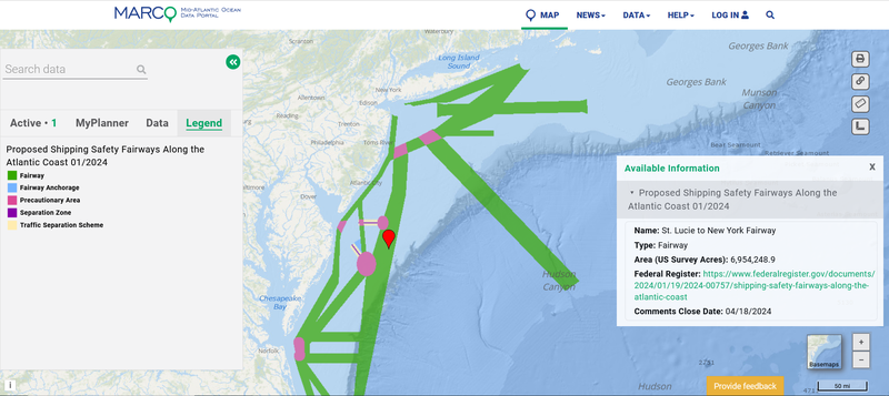
The fairways can be viewed on the Proposed Shipping Safety Fairways Along the Atlantic Coast 01/2024 map layer, which can be found by clicking on the “USCG Proposed Areas and Studies” dropdown in the Maritime theme. Members of the public can view the Federal Register notice for full background on the proposal and instructions for submitting comments.
On March 25, the Coast Guard posted an additional Federal Register notice announcing its original April deadline for public comment had been extended to May 17, 2024. The notice also announced that a meeting would be held to gather further input from the public on April 17 at 6 p.m. at Stockton University. The address for the meeting is 101 Vera King Farris Drive, Galloway, New Jersey, in the L-Wing Building, Classroom 112.
The fairways were identified through a series of port access route studies (PARS) that were conducted beginning in 2019 on the approaches to major ports along the Atlantic Coast, as well as an Atlantic Coast Port Access Route Study (ACPARS) completed in 2017. The studies gathered a wide range of data and stakeholder input on potential conflicts with offshore wind projects, future maritime commerce trends, port infrastructure changes and many other factors to evaluate the adequacy of existing routing measures and determine whether changes were necessary to safely accommodate vessel traffic.
The purpose of fairways is to preserve the safe and reliable transit of vessels along well-established traffic patterns and routes. While vessels are not required to use them, fairways are designed to keep traditional navigation routes free from fixed structures, such as offshore wind energy installations, that could impact navigation safety and impede other shared offshore activities.
Users can click any of the fairways and other features on the map for pop-ups identifying what the areas are, their names, their total acreage, and a link to the Federal Register notice. It is recommended that Portal users also activate the Routing Measures map layer in the Maritime theme or use the Nautical Charts basemap to view connections between the PARS proposals and existing traffic lanes, fairways, separation zones and precautionary areas.