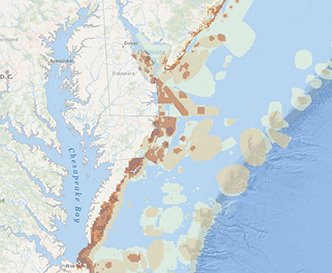
A collection of nine new map layers on Marine Planner will help to begin fill a gap in available data related to recreational use in the Mid-Atlantic. The maps present a regional picture of the beachfront and offshore areas in the Mid-Atlantic that are in high demand for a wide range of recreational activities, including boating, fishing, surfing and beachgoing.
The new layers can be found under the Recreation tab. They are the product of a series of surveys and participatory meetings in each state that explored recreational use in the five-state region. All states employed a participatory GIS (Geographic Information System) approach, which invited local recreation users to a meeting to map areas of interest. While New York used a slightly different data collection approach, the other our states – Delaware, Maryland, Virginia and New Jersey – used a common methodology to map where the public conducted more than 20 types of recreational activities.
The data from all states was reconciled, making it possible for Marine Planner users to view the data by state or as a region. Those layers are presented in a color-coded map format, with darker areas indicating where more different types of recreational activities regularly take place.
Although some of the data represented in the new layers were previously available on state level websites and other products, this marks the first time users could view and directly compare the recreational use information at a regional scale.

The new map layers present a consolidated view of all the recreational activities that take place in a given area. The Delaware, Maryland and Virginia state portal sites contain maps with additional details at particular locations. To access those sites, click the green “More Info” icons to the left of each layer title and then click “Source.”
A few unique data categories have also been added to Marine Planner for New Jersey and New York. A New Jersey Sport Ocean Fishing Grounds layer illustrates additional known fishing sites, as identified by the state’s charter boat, party boat and private boat captains. In New York, options are available to explore surfing, wildlife viewing and recreational fishing hot spots. Additional New York recreational information is available on the state’s Geographic Information Gateway.
The layers bolster an extensive collection of recreational information that was already available on the Portal. This includes recreational boating layers that illustrate popular routes and destinations, as well as coastal recreation layers that cover hot spots for sightseeing, diving, underwater activities and beach tourism (see our Ocean Stories feature for details). The Portal Team is working with state and regional agencies to identify additional recreational data that can be added to Marine Planner in the future.