
View areas that have been designated or proposed by the U.S. Fish and Wildlife Service (USFWS) as critical habitat for endangered and threatened bird species with a pair of new map layers on the Portal.
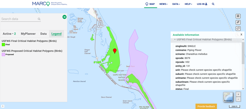
Proposed and final USFWS critical habitat areas for birds in Cape Hatteras, N.C.
The USFWS Final Critical Habitat Polygons (Birds) and USFWS Proposed Critical Habitat Polygons (Birds) layers can be found in the Habitat or Marine Life themes in Marine Planner. The layers were produced by filtering the USFWS’s Critical Habitat for Threatened & Endangered Species mapper to only show vital areas for bird species, such as the piping plover and red knot in the Mid-Atlantic. Users should visit the USFWS tool to view critical habitat areas for inland fish, bats, insects and other animals in the region.
A critical habitat is a specific geographic area that contains features essential for the conservation of a threatened or endangered species and that may require special management and protection. Federal agencies are required to consult with the USFWS on actions they carry out, fund, or authorize to ensure that their actions will not destroy or adversely modify critical habitat. These areas provide notice to the public and land managers of the importance of these areas to the conservation of a listed species.
Users can click any area on the map for a pop-up containing details on the species which depends on that area and its protection status.
A collection of nine maps showing critical habitat areas designated or proposed by the National Oceanic and Atmospheric Administration’s National Marine Fisheries Service (NMFS) were also recently added to the Portal. The maps show critical habitat areas for some species that are managed jointly by the USFWS and NMFS, such as the Atlantic salmon in coastal Maine. The Portal’s critical habitat data will continue to be updated to reflect any newly proposed areas or those that undergo changes in status.
Related Data

Users can view these critical habitat maps in combination with hundreds of map layers depicting marine bird species on the Portal. The Marine Life theme contains maps showing migration routes for tagged birds as well as a “Birds” dropdown containing dozens of marine bird distribution products for spatial groups (e.g., nearshore species and offshore species), ecological groups (e.g., surface plungers, benthic/bivalve eaters), species of concern (e.g., state-listed species), and stressor groups (e.g., higher collision sensitivity). Users may also search the Marine Life Library (Species Specific) theme for maps showing monthly relative density for nearly 50 marine bird species.
Questions? Contact us at portal@midatlanticocean.org.