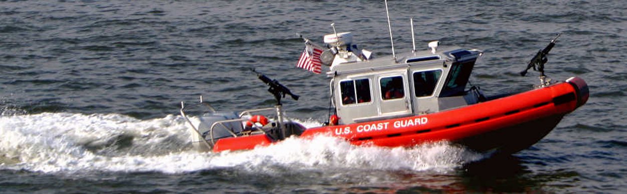
OCEAN STORY #17
Real-time tracking helps solve conflicts between vessels and other maritime activities
learn more

Approaching potential conflict in a busy ocean

Recently, with the help of the Data Portal, a key stakeholder – the Coast Guard – was able to use the best available data, which they helped create, to participate in important ocean planning dialogue.

In the byways of the busy Mid-Atlantic the Coast Guard has the responsibility and authority to maintain the safety and security for vessels of all kinds.

"The ocean is getting very crowded," said former 5th district Chief of Waterways Management Division John Walters. "The areas of intersection between various users is ever increasing, there is ever a demand for more activity on the ocean."

Walters, now retired, said the Coast Guard recognized a pressing need to engage in ocean planning with the designation of wind planning areas established throughout the Mid-Atlantic in areas traditionally used as shipping corridors – visualized in the map above.

Legend

All Vessels (2012)

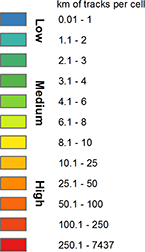
Mapping a data goldmine

Luckily, the Coast Guard had been gathering data regarding maritime vessel traffic called the national Automatic Identification System (AIS) that would help them participate in the wind energy conversation in a whole new way.

"While AIS receivers were first required for vessels carrying over 300 gross tons starting in 2002 as a result of the Maritime Transportation Security Act, it has only been since about 2009 that a majority of vessels are fitted with AIS transponders creating a more comprehensive picture of vessel traffic along coasts and out to 24 nautical miles on the Continental Shelf.  Now, according to the Coast Guard, the AIS system currently receives 92 million AIS messages per day from approximately 12,700 unique vessels,” said Portal team member and lead scientist for The Nature Conservancy Gwynn Crichton. “When the Coast Guard began requiring vessels to carry AIS transponders, it was for the express purpose of improving security and navigational safety. They never suspected that these data would suddenly have this huge utility and relevance for ocean planning or that there would be a demand to analyze past, present or future traffic patterns in relationship to other ocean uses like offshore wind or whale migration pathways."

"AIS data have become a treasure trove of information," Walters said. "We're not looking at one or two ships anymore; we're able to look at a whole year's worth of data to determine where shipping is occurring. Prior to AIS that information was very limited. A shipping company may know about its own ships, but it wouldn’t know anything about other ships. The Coast Guard would only know of transits if it was positively informed by a vessel in transit."

"The need for data to work in the current world cannot be understated," Walters said. "For us and the Bureau of Ocean and Energy Management, AIS data is critical to ensuring safety and navigation off-shore."

New data drives new conversations

Working together with NOAA’s Office for Coastal Management and the Marine Cadastre team, the Mid-Atlantic Ocean Data Portal team has been able to help the Coast Guard visualize multiple years of AIS data in the Marine Planner, giving the maritime community—perhaps the most ancient of ocean uses--a visual presence in the landscape of other ocean uses including the proposed wind planning areas both in New Jersey and elsewhere.

"Having those data in such a ready-made format where they can go to one place and look at potential conflict areas between potential offshore wind development and shipping routes has been really helpful to the Coast Guard’s ability to ensure their interests are considered as the Bureau of Ocean Energy  Management moves forward with leasing and permitting offshore areas for wind," Crichton said.

"We were thrilled that the Coast Guard could use the Mid-Atlantic Ocean Data Portal to help them communicate some really important information to another federal agency," Crichton said.

Legend

Habitat for Soft Corals (Modeled)
Loading...

Anchorage Areas
Loading...

Exploring new uses, partnerships through mapping ocean data

Apart from tracking shipping data, the Coast Guard has recognizes several other ways the data in the Portal can help them achieve their missions.

"One of the other aspects that have helped us out was the mapping of coral," Walters said. "We had no understanding of where the essential fish habitat was, what it was nor again where the coral was. If we’re looking at the creation of off-shore anchorages and aids to navigation we need to know that the bottom is clear of coral."

In addition to knowing where cold water coral exists, Walters said the accumulation of data around fishing is also very helpful for the Coast Guard.

"In years past it’s been very difficult to obtain any information about where fishing activity occurs," Walters said. "Through the efforts of MARCO and its stakeholder outreach I think fishermen both commercial and recreational have been able to fill a vacuum. We had no visibility about how fishing activity interacted with commercial shipping."

"Essentially the portal provides one stop shopping to determine multiple objectives," Walters said.