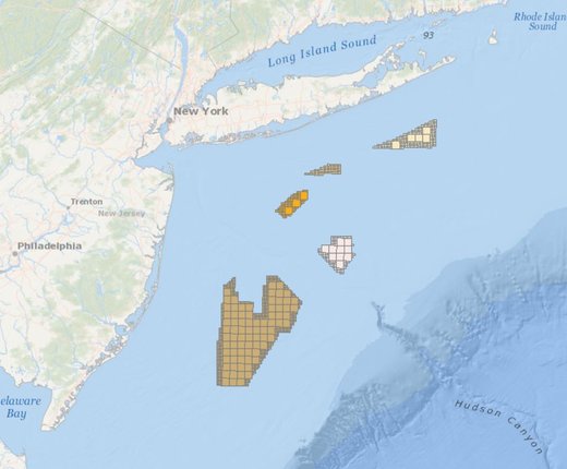
The Portal’s BOEM Wind Planning Areas map has been updated to include nearly 800,000 acres of newly designated Wind Energy Areas (WEAs) in the New York Bight, between Long Island and the New Jersey coast. The map can be found by clicking on the Planning and Lease Areas dropdown within the Renewable Energy theme.
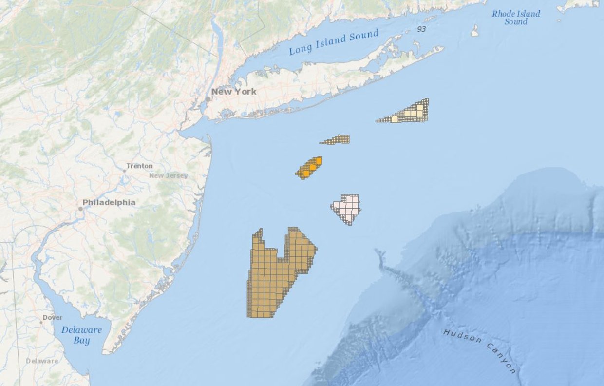
The map includes five new WEAs, labeled in the legend as (from north to south) Fairways North, Fairways South, Hudson North, Hudson South and Central Bight. Three older Portal maps that depicted previous steps in the WEA identification process -- BOEM Identified NY Bight Call Areas, BOEM Identified NY Bight Draft Wind Energy Areas, and NYS Identified Wind Energy Areas of Consideration – have been retired.
The goal of BOEM’s Area Identification process is to identify the offshore locations that appear most suitable for wind energy development taking into consideration coexistence with ocean users. As part of this process, BOEM removed areas of highest conflict from consideration. BOEM received input from the public and other governmental agencies through the Call for Information and task force meetings as part of the process. The New York Bight WEAs are located in an area of shallow waters between Long Island (to the north and east) and the New Jersey coast (to the south and west). These areas have the potential to help states meet their offshore energy goals.
BOEM will now prepare an environmental assessment (EA) to consider potential environmental consequences of site characterization activities (i.e., biological, archeological, geological, and geophysical surveys and core samples) and site assessment activities (i.e., installation of meteorological buoys) associated with issuing wind energy leases in the WEAs. The EA also considers project easements associated with each potential lease issued, and grants for subsea cable corridors in the New York Bight.
As part of this process, BOEM is seeking comments on considerations to be included in the EA. For more information on the WEA’s and how to comment, visit https://www.boem.gov/renewable-energy/state-activities/new-york-bight.
The Portal contains several additional map layers depicting federal offshore wind lease wind areas, the sites of operational turbines and submarine power cables, terrestrial electric infrastructure and more. Click on the Renewable Energy theme in Marine Planner to view our full map collection or visit or Data Catalog for a full list of maps, related links and downloads.